First experiences to collect electrical measurements have been implemented employing Syscal Pro system. This instrument was very useful to train students on the field but unfortunately also too slow compared to the size of the sample area and the resolution needed for archaeological tasks.
To go over this issue, in autumn 2007 a survey in collaboration with Michel Dabas has been started employing the Automatic Resistivity Profiler (ARP©). This system has been developed in France by the GEOCARTA company, a CNRS France spin-off. The principle of ARP© is rather simple, relying on the standard galvanic electrical method, used widely for different applications since its discovery by Marcel and Conrad Schlumberger in the 1930s. The ARP© system was first designed for agricultural applications in 2001. It was not until 2004, however, that the system was released for archaeological surveying, because of the need to enhance its positional and measurement accuracy.
The surveyed area involves the whole of the Aiali site and its surroundings to a total extent of about 30 hectares.
All the raw data have been processed by a 1D median filter along transect first and then interpolated by a spline bicubic process on a squared mesh (40 cm × 40 cm for investigation depths 0–50 cm & 0–100 cm but 50 cm × 50 cm for the deeper one (0–170 cm). In this occasion we show the maps of apparent electrical resistivity at different depths of investigation using a black & white colour scale.
The ARP© data makes it possible to add new and extremely significant information of the surveyed area but also to integrate information on known features. The survey also produced a high resolution DTM of the investigated area.
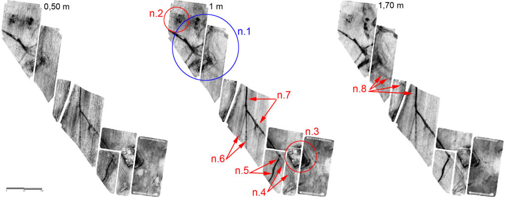
Legend:
n.1 – buildings of the roman villa
n.2 – buildings of the roman villa
n.3 – medieval mound
n.4 – road
n.5 – ditch
n.6 – filed boundaries
n.7 – filed boundaries
n.8 – paleo-river bed